
1500 miles from any ocean, water infused with salt from an ancient sea rises up, forming one of the rarest natural communities in Nebraska. A generation ago, all could have been lost to urban growth and the plow, but today restoration and hope are on the rise.
Enlarge
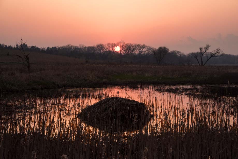
Photo and Story by: Michael Forsberg
It is just before dawn in Nebraska’s eastern saline wetlands. You sit quietly on the edge of a salt marsh – a mearly level pan of sparse vegetation and mud. Just in front of you water laps in rhythmic beats at the shoreline. On the opposite shore, the growing light gently begins to fill in the dark spaces, giving definition to the dusky shapes that have been murmuring in the distance. They are a mixed flock of shorebirds and waterfowl on migration – lesser yellowlegs, Baird’s sandpipers, killdeer, blue-winged teal and northern shovelers.
As the sun crests the horizon, cliff swallows that have wintered in Central America tug nesting materials from a muskrat hut. Painted turtles periscope up from below the surface. All around you, red-winged blackbirds and sedge wrens begin their morning chatter. Then a northern harrier swoops down, strafing the cattails, and blows the entire crowd off the water.
You leave the water’s edge and follow a game trail that takes you to a creek crossing littered with mink and raccoon tracks. The trail eventually leads you to the base of a hill where cattail and cordgrass meet big bluestem, and where a thread of flowing water bubbles up from a clear cold spring.
From the spring, you begin to climb up the hillside prairie while meadowlarks and dickcissels sing in stereo declaring their territories from shrubby perches. And as you reach the top you look around and begin to see more clearly where you are – the farmland and acreages, the powerlines, and the county road, and off in the distance, the hazy line of Lincoln punctuated by the state capitol.
If someone would have blindfolded and dropped you here in the half light of dawn, you might have felt you were in wilderness. But you are just a few miles away from the city of Lincoln, population 300,000, the second largest population center in the state, and growing.
An Ancient Wetland
This saline wetland landscape is a remnant of a once vast prairie wilderness that comprised a rich diversity of life in North America’s Great Plains. We can only imagine what it was like in this part of eastern Nebraska when this country was truly wild. When long before Euroamerican settlement, Plains Indians and the indigenous cultures before them recognized this rich tallgrass prairie landscape and these salt basins as home.
Perhaps the closest we can come is the writings of W.W. Cox, who described the Lincoln landscape of July 1861 this way:
“As we viewed the land upon which now stands this great busy city, we had the exciting pleasure of seeing for the first time a large drove of beautiful antelope, cantering across the prairie about where the government square is (9th and O streets). We forded Salt Creek just by the junction of Oak Creek, and what a struggle we had in making our way through the tall sunflowers between the ford and the basin. There was something enchanting about the scene that met our eyes. The fresh breeze sweeping over the salt basins reminded us of the morning breezes at the ocean beach.”
If we were to take his same path today, we would start in the heart of downtown Lincoln, pass through the historic Haymarket District, by Pinnacle Bank Arena and Memorial Stadium, and probably hop on a bike trail to cross a bridge near the shoreline of Oak Lake and end up wandering the residential neighborhood of Capitol Beach, once the largest saline wetland in the basin before it was transformed and eventually cut in half by the Interstate. One can only imagine what W.W. Cox would think standing there now. He probably wouldn’t believe his eyes.
Jewels of Salt Creek
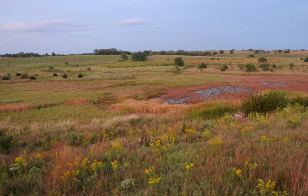
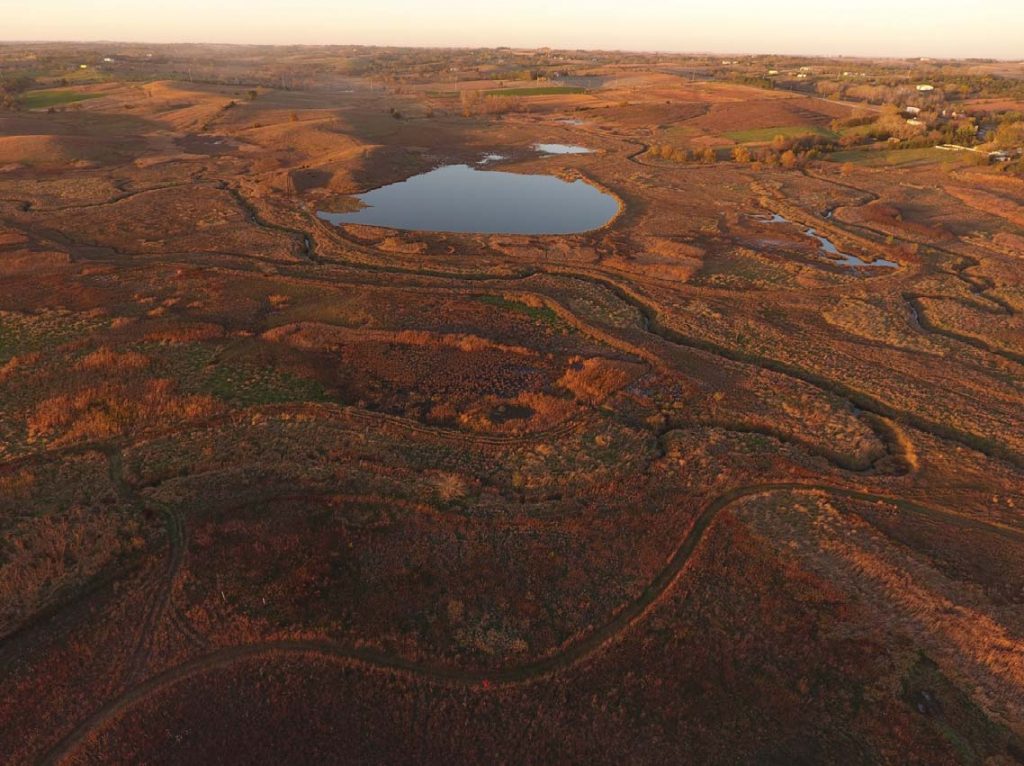
Nebraska’s saline wetlands are rare jewels found only within the Salt Creek watershed, a roughly 52-mile-long, 1,627 square mile drainage that encompasses much of Lancaster and Saunders counties, and flows generally southwest to northeast before merging with the Platte River near Ashland, just above Eugene T. Mahoney State Park. Contained within this watershed is a roughly 12-by-25-mile-long elliptical dish shaped by Salt Creek and its floodplain. It is where the city of Lincoln sits, and where roughly 20,000 acres of saline wetlands once were.
Born in the swales and depressions within Salt Creek and its tributaries, the saline wetlands contain a diverse assemblage of habitats including saline marsh and meadows, salt flats, and spring and seep fed wetlands, bisected by streams and surrounded by tallgrass prairie. Their unique natural citizenry includes salt loving plants with names like sea blite, saltmarsh aster, and saltwort, the latter found nowhere else in the state. More than 250 species of migrating and resident birds have been documented since around 1900. In addition, thousands of species of insects and other invertebrates, many of them wired for a life among saline soils, can be found here – including one of the rarest creatures on earth, the Salt Creek tiger beetle.
The saline wetlands’ magical ingredient is groundwater that emerges at the surface through a myriad of seeps and springs and is nearly as salty as the ocean, coming from deep upwellings of water infused with salt passing through layers of limestone bedrock and Dakota sandstone laid down ages ago when the Great Plains was a vast inland sea. It is this salt in the water that formed a white crust at the surface when the wetlands would periodically dry out that brought hope of economic opportunity to the area and helped establish Lincoln in the 1860s. The commercial salt mining industry was short lived, but it did serve its purpose long enough to help Lincoln set roots as a thriving community and Nebraska’s capital city.
Growth and Decline
To accommodate the growth of Lincoln over the next century and the inevitable building into the floodplains, saline wetlands were drained, filled in and covered. Salt Creek was channelized and straightened for flood control and to transport wastewater away from the city. As the channels were straightened and the banks modified the channel cut deeper, velocities of water in those channels increased, which had a direct effect on its tributaries that began to headcut and form faster and deeper channels themselves. Soon, groundwater tables were dropping, and periodic flooding that used to spread across the floodplain and infuse the groundwater connected with these wetlands could no longer be recharged. Other wetlands were being ditched, drained and filled for agriculture, and surrounding prairie grasslands were also being lost to the plow.
As topsoil ran off fields and entered waterways, saline soils were buried in sediment, and as banks began to slough off in incised channels, they began to cover up the seeps and springs that fed the streams. Later, other wetlands were filled in or used as landfill sites, or paved over for roads and parking lots, and housing and commercial developments grew north.
In short, as the city grew the wetlands suffered, and after a century of growth and development, only a small percentage of the original 20,000 or so acres of saline wetlands remained, mostly surviving in small fragments less than 20 acres in size, and highly degraded.

Wetlands are among the most productive and biologically diverse habitats on earth. They are the kidneys of the landscape, filtering our water of pollutants and converting them to less harmful substances. They control flooding by giving water a place to go and slowing down runoff and allowing water to absorb back into the soil. They recharge local water tables and aquifers. Sadly, they have been viewed more as a nuisance or an impediment to progress in our country’s brief history, and roughly half of all wetlands in the U.S. have been destroyed.
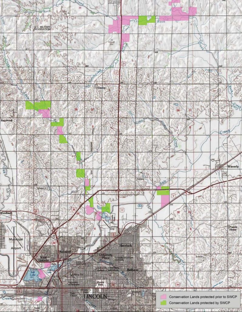
It wasn’t until the early 1980s that concerted conservation efforts began to officially protect eastern Nebraska’s remaining saline wetlands when the Lower Platte South NRD began purchasing easements, and when lands that became Arbor Lake and the Jack Sinn Wildlife Management Area were acquired by the City of Lincoln and the Nebraska Game and Parks Commission, respectively. In 1991, NEBRASKAland Magazine elevated the profile of saline wetlands, calling attention in a public way with a seminal article co-authored by Jon Farrar and Richard Gersib entitled “The Last of the Least.”
A Rare Beetle
Today, Nebraska’s remaining eastern saline wetlands are considered to be the rarest and most limited natural community in the state. In one way, their rarity represents what we have lost. But their rarity and increasing public awareness have also assigned them high priority for conservation. In the last 20-plus years, these remnant habitats are slowly being protected and increasingly connected, in part by the fate of a half-inch, water-loving beetle, a unique conservation partnership, and the care and dedication of many people.
In 2000, the Salt Creek tiger beetle was listed as an endangered species in the state of Nebraska. By 2005, the species was listed as federally endangered. “They are mud-loving, water-loving beetles,” said Steve Spomer, a Lincoln native who grew up collecting bugs and became a University of Nebraska-Lincoln entomologist and tiger beetle expert. “When other tiger beetle species go find shade to cool off, this beetle goes down to the water.” Spomer has studied these insects for nearly four decades.
Nebraska’s eastern saline wetlands have 12 tiger beetle species, but what makes the Salt Creek tiger beetle different from the others is that it is found almost exclusively on the salt concentrations. The portion of the salt flat nearest the center of the wetland is the wettest, keeping salts in solution, and salinity levels moderately high. Here, saltwort, a state listed endangered plant found nowhere else in Nebraska, thrives. Beyond the wetter, inner ring of the salt flat, evaporation frequently dries the soil surface, concentrating salt near the surface. Sea blite occupies this slightly drier, central portion of the salt flat zone. Inland saltgrass, dwarfed in stature and sparsely spaced, is often the only plant which can survive on the dry, salt-encrusted outer portion of the salt flat.
The greatest diversity of plants on a saline wetland is found in the saline meadow, a transition zone between the salt flat and prairie at the outer edge of the wetland. Closest to the salt flat, foxtail barley and marsh elder dominate, but many other species also grow here, including spearscale and saltmarsh aster. In the saline marsh, sago pondweed and saltwater bulrush thrive. The plants of a saline wetland are seldom arranged in so orderly a manner.
The boundaries between zones where one species or another is favored are constantly changing as soil saturation and salinity fluctuate, and a mixing and merging of plant species occurs. Frequently, the most consistently wet portion of a saline wetland is not at the center, but below seeps emerging from the base of hills at the edge of the floodplain, as illustrated here. Salt flats on large basins may have small depressions or “pans” which periodically hold water, where plants most tolerant of high salinity and saturated soils grow. ■
The post Success in the Salt Marsh appeared first on NEBRASKALand Magazine.


