
In the Loess Canyons region of southwestern Nebraska, landowners are making serious headway in fighting back eastern red cedar trees.
Enlarge
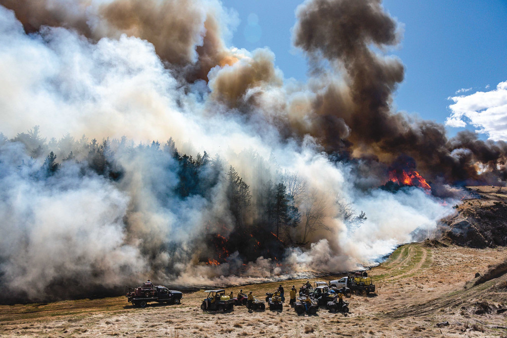
Photo by Eric Fowler, Nebraskaland Magazine
Story and photos by Eric Fowler
It happened slowly. Eastern red cedar trees were once found only in steep, moist corners of the landscape, rocky hilltops or islands in rivers where they were protected from the fires set by Native Americans to attract game or sparked by lightning that periodically swept across the Great Plains. When settlers arrived and fire was removed from the equation, this opportunistic invader began to creep out of its refuges and into the surrounding grasslands. Each year, cedars consumed more valuable grazing land and wildlife habitat. The front line advanced so slowly it has been dubbed the green glacier.
Now, after more than a century without these periodic fires, the prairies are one of the most imperiled and least conserved ecosystems in North America. Across the Great Plains, from Texas to the Dakotas, woody plants including cedars are expanding at a rate of 10 percent per year. Where the problem is at its worst, grasslands are now dense woodlands. Nebraska has lost 500,000 acres, or 781 square miles, of grassland since 2000 alone. That’s nearly the size of Lancaster County.
Efforts to control cedars are many and growing, but the problem is so bad, cedars are still winning the battle. In the Loess Canyons region of southwestern Nebraska, however, landowners are making serious headway. The key to their success has been working with their neighbors to reintroduce fire. With large, intense prescribed burns, they are killing trees from the ridgetop prairies, down the steep slopes and into the canyon bottoms. It is one of few places in the world where the rate of woody encroachment has been stopped. Soon, it may even be reversed.
With fire, they are melting the glacier.

The Problem
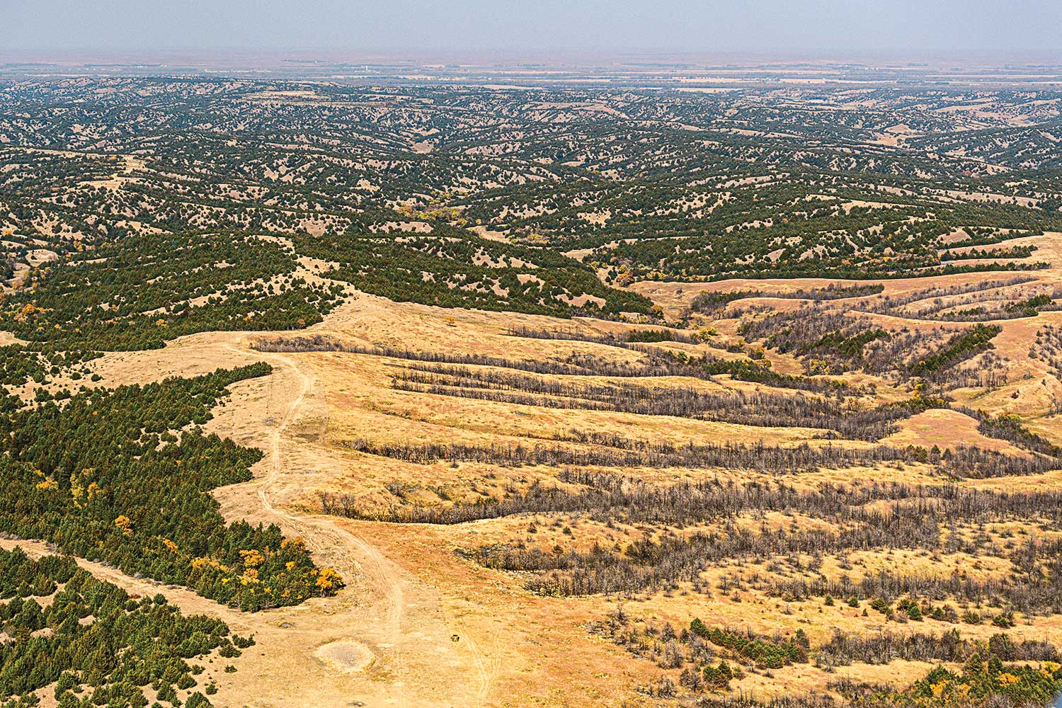
The Loess Canyons region encompasses a 330,000-acre triangle of land south of the Platte River between North Platte, Cozad and Curtis. The region’s present topography is related to its origin. At the end of the last glacial period, wind slowly blanked the area in loess, tiny particles of silt, clay and sand. Among the thickest such deposits in North America, the loess is highly erodible. It has evolved into a maze of steep-walled canyons that stretch like veins from the main creek draws, some leading north to the Platte River Valley and most south to the Republican River Valley. Cloaked in mixed-grass prairie, the canyons contain grasses and forbs, wildflowers that vary from the dry ridgetops to the moist bottoms. It is one of 35 Biologically Unique Landscapes identified in the Nebraska Game and Parks Commission’s Natural Legacy Project, its roadmap for recovering threatened and endangered plants and animals.
Many long-time residents tell the same story, about how, when they were children, or when their parents were, it was hard to find a cedar to cut for a Christmas tree. And why would you? In the Tree Planters State, home of Arbor Day, every tree is said to be good. There were fewer cottonwoods, box elder, ash and hackberry than there are today, and planting trees, including cedars, was encouraged for their value as shade and protection from wind for people, livestock and wildlife.
But eastern red cedar, a hardy, drought tolerant species native to Nebraska and much of the Great Plains, grows fast and produces up to 1.5 million seeds per tree. Some seedlings will grow near that tree, but germination is improved when the seeds are eaten and partially digested by birds. Wherever those birds land and deposit their droppings, cedars will grow.
Research by the University of Nebraska-Lincoln found 95 percent of cedar seedlings sprout within 200 yards of a mature, female tree. That means during its seed-producing years, a single tree can compromise 26 acres of grassland. And each female tree that sprouts and matures puts the next 200 yards of grassland at risk. Today, in the northern end of the Loess Canyons, cedars cover 90 percent of some properties.
“Trees are like compound interest,” said Russ Sundstrom, who has been ranching in the canyons south of Brady since 1993. “The worse it gets, the faster it goes.”
The problem is not unique. In the western United States, woody plants have increased on 108 million acres of grassland, an area more than twice the size of Nebraska, since 1999. In the Great Plains, the loss of grassland to woody encroachment is nearly equal to losses to land conversion for agriculture. The problem is progressing from south to north and east to west. Nebraska is on the edge of that advance.
The list of problems caused by encroachment is a long one. Compared to the many species of sun-loving grasses and forbs that typically would grow in prairie, few, if any, plants grow in the dense shade below cedars. More cedars means less grass for cattle. In some areas where cedars have displaced grass, landowners have been slow to adjust stocking rates and overgraze their pastures, further stressing the native vegetation and allowing non-native plants like cheatgrasses and smooth brome to invade.
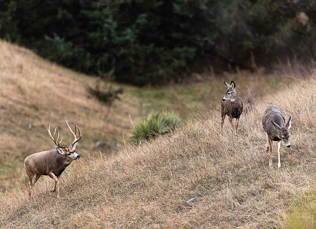
It also reduces available habitat for grassland wildlife. Grassland bird populations, including the greater prairie-chicken, bobwhite quail, grasshopper sparrows and Bell’s vireo, declined, as did the overall number of species. Mule deer and wild turkeys were displaced by the trees. Even insects, like the endangered American burying beetle, were affected.
Cedars deplete soil moisture, groundwater recharge and stream flow. With no grass to slow runoff, erosion on cedar-choked hills can be severe, reducing downstream water quality. Fewer acres of grass on School Trust Land reduces what can be charged for grazing leases on that land, which means less funding for schools. And the severity of wildfires increases where cedars are present, putting lives and property at risk. A wildfire south of Gothenburg in 2002 burned 40,000 acres.
The Epiphany
By the time landowners in the Loess Canyons realized how big the problem was, it was almost too late. The region had become one of the most cedar-infested in the state. But they attacked it anyway. Initial efforts focused on cutting, piling and burning trees. But they made little headway, and efforts were costly. Where landowners did cut, the soil disturbance led to ideal conditions for seeds to germinate, and a new flush of cedars sprouted, creating a stand often thicker than the one that had been removed. All the while, cedars were sprouting in the seemingly tree-free pasture behind them.
Prescribed fire was already being used in areas of eastern Nebraska and elsewhere to control cedars in grasslands. Doug Whisenhunt of the Natural Resources Conservation Service wondered if fire could also control mature trees in the canyons, and in 2000 convinced Mark Alberts to try a burn on his pasture on the edge of the Central Loess Hills northwest of Gothenburg. As was the case in the steeper Loess Canyons to the south, cedars were spreading from the steep slopes into open pastures.
The idea did not go over well with his neighbors. “The greatest ad campaign in this country, the most successful, has been Smoky Bear,” Alberts said. Prescribed burning “was something kind of new, and we had a lot of people mad at us. Mark was a four-letter word.”
But with the help of NRCS staff and some neighbors, they gathered a hodgepodge of equipment and burned 300 acres. “We kind of made up our burn plan as we went,” Alberts said. “If we burned today the way we did then, we’d probably go to jail.”
With just 30 percent mortality on cedars, the results of their fires were poor by today’s standards. But even that, Alberts said, was enough to turn some of the naysayers into some of today’s greatest advocates for prescribed fire in the region. And lessons were learned: Where Alberts had cut trees with a chainsaw in one location and left them lay next to standing trees, the dried, dead formed a perfect ladder fuel, taking the fire from the ground to the crown and through the stand, killing more trees. This cut-and-stuff method of controlling cedars had already been used elsewhere, but word of its effectiveness had not spread.
In 2002, Whisenhunt helped Alberts and a dozen or so other landowners form the Loess Canyons Rangeland Alliance, the state’s first prescribed burn association. With Alberts as the burn boss, they burned 1,300 acres. With grants from the Nebraska Environmental Trust and others, they purchased equipment to make burning safer and more efficient, including 200-gallon water tank sprayers that could slide into the back of a pickup, and then burned more acres in 2005.

Scott Stout, a Burwell native, began working on his wife’s family’s ranch north of Curtis when they married in 1999. He said he was “shell shocked” by the number of cedars in the region. When he wasn’t working cattle or farming, he was doing something to control cedars, which covered 20 to 50 percent of their pastures. He helped neighbors with one of those burns in 2005, and while he wasn’t overly impressed with the results, he could see fire was a better option than cutting and joined the burn alliance.
He continued to cut scattered trees to prepare for his own burn, but wasn’t happy with the time it took to move and pile those trees. Instead, he pushed them up against the dense stands on slopes too steep to cut. When he finally burned in 2008, he saw the same success Alberts had, but on a larger scale. Where previous burns had resulted in 40 to 50 percent mortality, Stout saw 70 to 75 percent.
“So by happy accident, we just started shoving cut trees up against live trees just to get rid of them and not thinking that it was going to apply that intense heat source there,” Stout said, noting that this cut-and-stuff approach to clearing prior to a burn is now the standard today.
Each year, as neighbors looked across the fence and saw the results of a burn, including not only fewer trees, but a lusher stand of grass, more joined the association. In 2008, there was enough interest that Alberts helped form a second burn association he still leads, the Central Platte Rangeland Alliance, in the southeastern portion of the Loess Canyons and in the Central Loess Hills to the north between Brady and Lexington. Stout took over leadership of the LCRA, became the burn boss, and continues in that role today.
The combined membership of both associations includes more than 120 individuals. In the Loess Canyons, members collectively own 264,000 acres, or 80 percent of the region. More join each year. That buy-in, and the fact that the groups and burns are led by landowners, has been their success. Working together on burns has rekindled something from days gone by, where neighbors regularly helped neighbors with their chores, knowing the favor would be returned. “I think it kind of got away from that here for a while,” Stout said. “But this group, it seems like it kind of developed a whole new sense of community. It’s really brought back the selflessness of people.”
That cooperation also allows them to burn several properties at once, often burning from one county road to the next in an area with very few roads, rather than one property, which might require cutting fire breaks through steep terrain. Now they build fire breaks in places where the terrain makes them easy to both create and defend.

Getting there was a process, as members weren’t sure how many acres they could safely burn in a day. “They started with a section,” said Andy Moore, coordinating wildlife biologists with Pheasants Forever, who has helped landowners in the Loess Canyons plan cedar-control projects since 2011. “And then there was a point where some of the members said: ‘We can’t do burns bigger than 2,000 acres because we can’t get around them in a day.’ They’ve proved that wrong. They’ve done burns bigger than that in a half day.”
To date, the largest burn conducted by the groups covered 4,500 acres, a daylong effort that covered property owned by 10 individuals. In 2020, LCRA members burned 22,000 acres, including several burns topping 3,000 acres. CPRA members burned another 7,500 acres, and a private contractor 6,500. In all, the groups have burned more than 150,000 acres, most of those since 2008.
The burns are meticulously planned, many by Stout, first as the burn boss and now as a technical service provider with the NRCS. And they are well attended, with more than 100 people showing up for some. They arrive in rusty ranch pickups or pulling trailers loaded with ATVs, each assigned a specific job and handling it without question. “Trying to get farmers and ranchers to cooperate, you might think it’s easier to pile BBs,” Alberts said. “We’ve never had an issue.”
The safety record of the burn crews is excellent. Rarely have fires spread outside the unit. More wildfires have been sparked while landowners burned piles of cut cedars during the winter, a process now combined with the prescribed burns.
“They’ve mastered the use of high-intensity fire,” said Dillon Fogarty, an assistant professor and woody invasion ecologist at the University of Nebraska-Lincoln, who studied the region as a graduate student and documented their success. “By doing that, they can manage the patches of trees, mature trees, the seedlings and the seeds during that single application of prescribed fire.”
After killing less than half of the cedars in those initial burns, “now some of the landowners aren’t pleased if they don’t kill 90 percent or more of the cedar trees inside a unit,” Moore said.
The groups are now looking at bigger burns, up to 10,000 acres, and at burning at times other than late-winter and early-spring, when most burns are currently conducted. They know they need to expand if they are going to keep restoring grasslands and maintain the ones they already have. To stay ahead of the problem, landowners need to burn every 5 to 7 years to control new cedar growth. Many have already burned their land twice, and others need to soon, before new trees get too big to control with fire alone. The second burn is easier, with little if any mechanical clearing required. And with so many acres having been treated, it is safer, with fewer cedars to send burning embers outside the burn units.
“We understand that it’s not a one-year, one-time fix-all,” Stout said. “We understand it’s a management process, and we have to go back and maintain it.”

Cost vs Benefit
Planning and preparing for these burns typically takes three years before the first drip torch is lit. Each landowner must get any necessary tree-cutting done, clearing fire breaks, large trees on the perimeter and scattered mature trees that might not burn. They also need to defer grazing on the property in the year leading up to the burn to ensure there is enough grass to fuel the fire, carry it through the unit and kill young cedars, and burn hot enough to consume the seeds still waiting to sprout. When their turn to burn rolls around, weather must cooperate. Drought can postpone burns for a year — and has more than once.
The cost of mechanical control can be daunting, averaging $250 per acre in the region. Where firebreaks must be cut by hand in dense stands on slopes too steep for heavy equipment, it might soar to $2,500. “That seems astronomical, and it is,” said Sundstrom. “But if you do that and can treat hundreds and hundreds of acres [with fire], and you don’t have that cost over a lot of acres, then it’s economical.”
Deferring grazing is another expense, as landowners must rent pastures elsewhere or providing hay to feed their stock. There are cost-share programs available from numerous sources (see sidebar) that Moore says typically cover 75 percent of these expenses.
Doing nothing to control cedars is not a good option, said Sundstrom, who sees both sides of the equation as a landowner and tree cutting contractor. Property taxes aren’t adjusted according to the amount of tree cover, even though the land can feed fewer cows. And the cost of control can quickly exceed the rental value, and it gets higher every year. If you aren’t willing or able to do it, Sundstrom said, “As high as property is right now? Man, sell it and go do something else.”
Some landowners still want to cut trees and not burn. “The thing that people don’t realize is there are so many other benefits to the prescribed burns,” Sundstrom said. “It’s instant fertilization. The grass is better and the cows like it better.”
When cedars are removed and sunlight reaches plants struggling to grow in the shade and the seeds of native grasses and forbs that have laid dormant, in some cases for decades, the response is instant. Annual forbs like annual sunflowers and ragweed are the first to explode, followed by the prairie grasses. “It amazes me how resilient that native grass is, and how it comes back,” Stout said.
Non-native, invasive, cool-season grasses like downy and Japanese brome grasses are also set back by spring prescribed burns. And with native grasses, such as side-oats grama and little bluestem, now growing where cedars once stood, ranchers can increase their stocking rates and their bottom line. Rather than needing 14 to 17 acres for each cow and calf he puts to pasture, Stout needs 8 or 10 acres. For those trying to make a living off the land, “it really does sell itself,” Stout said.
Sundstrom put a pencil to it a different way, and figured he increased the number of grazing days on his ranch by 40 percent, and his profit, after expenses, by more than 200 percent. “That’s the important number there,” Sundstrom said. “I always felt like whatever I did for tree control, with increased grazing, paid for itself in 3 to 5 years.”
A Model for Others
Around the world, woody plants are invading grasslands. Few places have been as successful at controlling the invasion as they have in the Loess Canyons.
Since 2014, 180,000 acres of the region have been a working laboratory for researchers at the University of Nebraska-Lincoln. With full support of landowners, students have studied the response of grassland plants, birds, the American burying beetle and other topics in response to fire.
The work in the canyons served as the framework for the Working Lands for Wildlife program recently released by the NRCS to guide grassland wildlife conservation in the Great Plains. Now people from around the world are looking to these landowners, researchers and partners to learn how they did it.
“Very few groups, and none in Nebraska, have gotten to the level where they’re using fire to manage all of the stages [of cedar growth] at once,” Fogarty said. “I don’t want to take away from what good work is being done in other places, but the Loess Canyons is just the example to look up to right now.”

Stout said landowners shrug off the attention. “It’s kind of funny, it’s just another day for them,” he said. “They don’t realize what they’re doing. … They’re just trying to keep their operations afloat.”
In the process, by banding together, they are winning the battle, melting the green glacier and restoring a unique — and necessary — landscape.
Bad News for the Beef State
Cows don’t eat cedar trees.
In Nebraska, the beef state, where 1.8 million cows and calves graze in pastures across the state, the cost of eastern red cedar encroachment into rangeland is significant and growing.
In 2019, Nebraska lost 419,000 tons of range production to woody encroachment. Kansas lost 1.5 million tons of forage that year, and Oklahoma 4.5 million tons. “We’re following the trajectory of those states, said Dillon Fogarty, a range ecologist at the University of Nebraska-Lincoln.
The lost grass could feed 88,000 cows and calves, and replacing it would require 700,000 round bales of hay. The cash rental rates of the pasture lost would amount to $18 million. “Our rangelands are worth a whole lot in this state,” Fogarty said. “Woody encroachment is taking an increasingly bigger piece of the pie every year.”

If you have even one seed-producing cedar tree where you don’t want more, you have a problem. The species is spreading in every corner of the state, and even in the Sandhills, often where planting cedar windbreaks introduced a seed source where there was none. In all, 8 million acres of intact grassland are at risk of future encroachment.
Though control efforts are underway, Fogarty said the rate of encroachment continues to increase, a troubling fact to range managers. Part of the problem is that control has often focused on removing mature trees, while seed from those trees sprouted in adjacent, intact grasslands, which grew, produced more seed and affected even more acres.
The University and others are now preaching one message: Protect and grow the core. The core is the intact grassland, far enough from the seed source that it hasn’t been infested. From there, work backward towards the forest, or even the windbreak, removing seedlings and seed trees. The most effective and least costly tool to use for these efforts is prescribed fire. Once those acres have been protected, go after the scattered trees in the grassland and, finally, the mature stands.

There are numerous sources of cost sharing assistance for cedar control efforts. Pheasants Forever has nine coordinating wildlife biologists around the state who help landowners connect with those resources. Andy Moore fills that role in the Loess Canyons, working out of the Nebraska Game and Parks Commission district office in North Platte. He said the Natural Resources Conservation Service’s Great Plains Grassland Initiative is one source that has grown significantly in both manpower and funding in recent years, helping offset the cost of mechanical removal, prescribed burn planning, deferred grazing and more. The Nebraska Forest Service provides assistance in developing fire breaks around burn units and structures within the units. Game and Parks’ Natural Legacy Program can fill in the gaps.
Other sources of funding and technical assistance in the state include The U.S. Fish and Wildlife Service, Natural Resources Districts, the Nebraska Environmental Trust and conservation groups, including the Sandhills Task Force, The Nature Conservancy, the National Audubon Society, Rocky Mountain Elk Foundation, Quail Forever, National Wild Turkey Federation and the Bird Conservancy of the Rockies. Seventeen formal prescribed burn associations in the state work together to tackle the problem.
Scott Stout, a rancher and member of the Loess Canyons Rangeland Alliance, said the best time to start controlling cedars is when you have a few. Wait, and the problem will grow like it did in his region, one of the most infested in the state prior to widespread control efforts. “If you don’t start now, it’s going to get out of hand.”
The post Melting the Green Glacier – Eastern Red Cedar Management appeared first on Nebraskaland Magazine.


